Not the usual cargo
In which we truck in some pollen and get ready for more storms.
Here we go again
More severe weather is headed for the ~Central U.S.
— Stormchasernick (@stormchasernick) 2:15 PM ∙ Apr 2, 2023
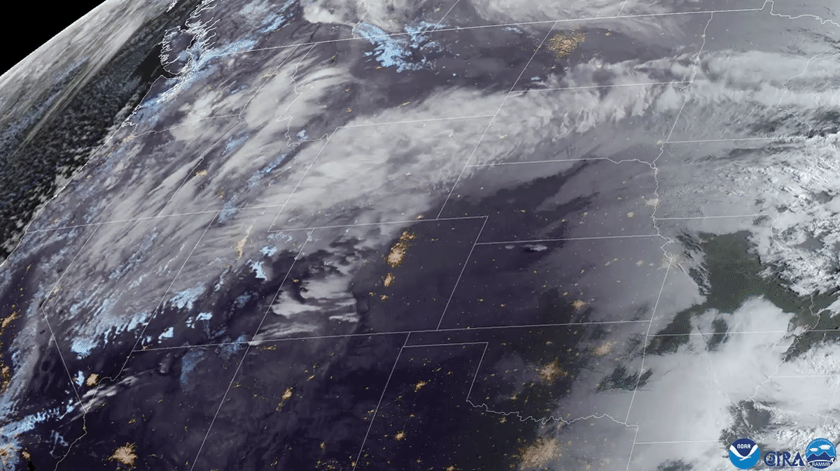
Here’s a look at the larger picture, which includes heavy snow and blizzard conditions. There’s weather action all of the place!
** Be Weather Aware**
— National Weather Service (@NWS) 11:28 PM ∙ Apr 3, 2023
Intensifying system with high winds, critical fire threats, & swaths of heavy snow will morph into a northern blizzard, significant Central U.S. severe weather outbreak, & extremely critical fire weather threats on Tue.
If you’re asking yourself “Hey, I wonder what this looks like from space?” Well, I’ve got you covered.
As the sun rises over the U.S. today, @NOAA's #GOESEast 🛰️ can see a large weather system bringing an impressive late season snowstorm to the Rocky Mountains today. There is also a Blizzard Warning in effect for parts of the Northern Plains.
— NOAA Satellites (@NOAASatellites) 4:32 PM ∙ Apr 3, 2023
Latest: weather.gov
And if you want a solid breakdown of what to expect with this event, MyRadar and Matthew Cappucci have one. There’s a WaPo article too if you’d rather read.
Another widespread episode of severe weather, including the risk of a couple strong tornadoes, is expected on Tuesday across the Mississippi Valley. MyRadar meteorologist @MatthewCappucci has an update on what to expect.
— MyRadar Weather (@MyRadarWX) 8:05 PM ∙ Apr 3, 2023
youtu.be/XHJSSMw1yPk
This looks like it might be a little more mild than the last event, but the potential for sever thunderstorms and tornadoes are still there. Some of these areas haven’t had a chance to recover from the last set of storms.
Break out the allergy meds
I think we’ve got enough pollen where I’m at without “trucking” it in 😄
Alrighty gang! Did you see a speckled car in your driveway Sunday morning?
— Matthew Cappucci (@MatthewCappucci) 2:55 AM ∙ Apr 3, 2023
We had strong "warm air advection" from the southwest before Saturday's cold front. That's why it was warm. But we trucked in TONS of pollen from the Deep South. That was "scavenged" by the rain. @fox5dc
NOAA Science Report
That is indeed what it’s called. Worth a quick skim I think. That page has a few headlines on it and then there’s a link at the bottom to download the full report.
Still looking like we’ll dry out
If you’re in NorCal, it looks like there might be one more shot in the near future for wet weather, but then we’ll be drying out. Some SF Chronicle articles if you’re interested in more:
- SF Chronicle/Apple News - Gerry Díaz
- SF Chronicle/Apple news - Michelle Apon
A report of a different kind
We previously covered Ian being retired as a name for hurricanes. Here’s a few reasons why.
The full report on Hurricane #Ian is out:
— MyRadar Weather (@MyRadarWX) 1:46 PM ∙ Apr 3, 2023
- Category 4 at landfall in FL
- 66 direct deaths (6 to 101 yrs old)
- $112.9 billion in damage (3rd costliest on record)
- 10-15 ft peak storm surge
- 10-20 inches of rain across Florida (26.95 inches max in Grove City)
- 15 tornadoes
How about some not-so-local weather?
Let’s go to Japan! A bit too hot maybe but you gotta love the cherry blossoms.
Much of Japan had the warmest March in recorded history!
— Sayaka Mori (@sayakasofiamori) 11:46 AM ∙ Apr 3, 2023
The unprecedented warmth has led to a record early bloom of cherry blossoms in many places🌸In Tokyo, the sakura season is almost over.
See you next time weather fam
Keeping it short this time since we’ve had so much going on the last week or so. Take care all!
Rainbow at sunset 🌈 #CAwx
— Dustin Mulvaney (@DustinMulvaney) 2:32 AM ∙ Apr 3, 2023
Weather Feed is a reader-supported publication. To receive new posts and support my work, consider becoming a free or paid subscriber.


