I’ll have a double please
Yes, I’m sure.
This post is going to be a bit different. We’re going to focus on something that happened during the last storm system that hit California.
Let’s take an initial look
Take a few seconds to click the video and watch it. Low pressure systems rotate counter-clockwise in the northern hemisphere, and low pressure systems generally bring unstable weather.
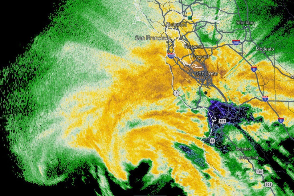
Last several hours of radar data out of San Francisco via @RadarOmega
— Steve Copertino (@TheSteveCop) 11:36 PM ∙ Mar 21, 2023
Can't say I've seen two meso-lows Fujiwara off the California coast like this before. Numerous reports of wind damage have been coming in as these produced gusts of around 60 - 80 mph. #CAwx
That’s like pretty low low.
It is fair to say yesterday's storm was unprecedented. We've never experienced a March storm as strong as the one we just went through. Pressure dropped to 984.4mb, beating the monthly record of 990.2mb.
— Drew Tuma (@DrewTumaABC7) 12:27 PM ∙ Mar 22, 2023
So why is this so neat?
It’s not unheard of, but there were two smaller low pressure systems that sort of rotated around each other and became one.
This process, when 2 or more local low pressure minima (i.e., regions of cyclonic vorticity) rotate about a common center, is called the "Fujiwhara Effect." #CAwx
— Daniel Swain (@Weather_West) 6:23 PM ∙ Mar 21, 2023
Say it with me: the Fujiwhara Effect (or watch a video)
The low pressure systems that combined off the coast of California were fairly small, but this effect can happen with hurricane level systems too. We just don’t see it super often in California.
Full 24 hour radar loop of the bomb cyclone and its meso-vortices making landfall in the Monterey Bay Area Tuesday afternoon--along with alerts/storm reports.
— Dann Cianca (@danncianca) 9:02 AM ∙ Mar 22, 2023
#CAwx @KION546
Enjoy the show
Here are a couple of loops that show the systems either joining, or the resulting low after they joined. It has an eye!
This is just……incredible
— Drew Tuma (@DrewTumaABC7) 10:58 PM ∙ Mar 21, 2023
Incredible radar loop and if you look closely the @MyRadarWX detected lightning ⚡️
— Erica López (@EricalopezWX) 11:06 PM ∙ Mar 21, 2023
Low pressure has consolidated into single vortex with a center of circulation just west of San Mateo. Given very slow expected motion in coming hours & very heavy rainbands training over San Mateo/Santa Clara/Santa Cruz Counties, flash flood concerns may commence shortly. #CAwx
— Daniel Swain (@Weather_West) 11:00 PM ∙ Mar 21, 2023
There was of course, a lot of wind
Remarkable storm event continues to unfold near southern coast of the SF Bay Area. Rapidly deepening low pressure w/multiple centers of rotation has been slinging bands of heavy rain & very strong wind gusts ashore for hours. Next in line: San Mateo coastline. #CAwx
— Daniel Swain (@Weather_West) 9:20 PM ∙ Mar 21, 2023
We used to ride this ferry, and there were several reports of the wind busting windows in San Francisco and the East Bay.
I'm on @GoldenGateFerry to SF and after 10+ minutes of trying to dock at the Ferry Building in SF, the Captain has decided we cannot safely dock and will return to Larkspur. People are getting seasick. I'd rather be safe than sorry. #cawx
— Dave Rhoads (@daverhoads) 11:04 PM ∙ Mar 21, 2023
Even more info
If you want to read/watch some more, here you go.
Weather Feed is a reader-supported publication. To receive new posts and support my work, consider becoming a free or paid subscriber.


