There are two hail puns in this newsletter
In which we take a ride across the US and put graupel vs. hail to rest.
So remember last time
When I said “Weather impacts us all. We often think a storm is done after it passes us by, but that’s not really true.”
Well, there’s a super cool video showing our last storm (probably not the correct technical term at this point) sweep pretty much across the entire US. Super neat.
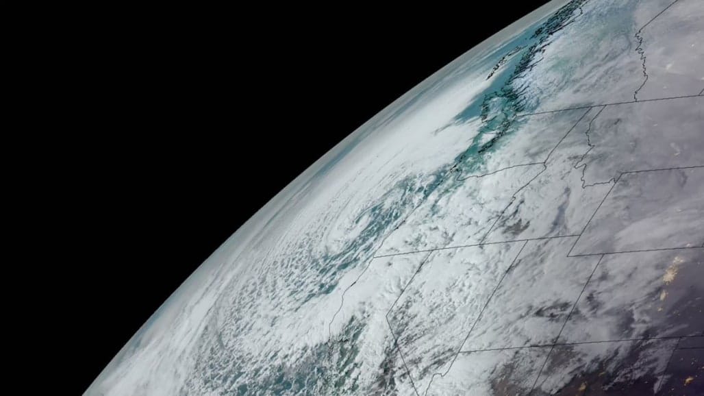
This past week, a massive winter storm made its way across the U.S., blanketing parts of the country in snow while bringing severe weather and tornadoes to others.
— NOAA Satellites (@NOAASatellites) 1:34 PM ∙ Mar 3, 2023
Learn more about this week's #EarthFromOrbit video: bit.ly/3ZiBAnW
That storm caused a lot of severe thunderstorms and tornadoes.
Severe thunderstorm warning issued for parts of Colbert, Franklin, and Marion counties in Northwest Alabama
— James Spann (@spann) 3:51 AM ∙ Mar 2, 2023
And a whole lot of power outages.
Power flashes in south Dallas. #txwx
— Scott McClellan (@ChaseTheWX) 12:43 AM ∙ Mar 3, 2023
Transformers blowing as Dallas braces for 60-80 mph winds. Tornado warning in effect for southeastern parts of the metro.
— MyRadar Weather (@MyRadarWX) 12:36 AM ∙ Mar 3, 2023
@MatthewCappucci is covering it all:
Here is footage of a tornado earlier in Shreveport near Bert Kouns around 5:40 p.m. Storms this evening will continue to be capable of producing short-lived tornadoes . Be prepared to take cover in advance of storms and when Tornado Warnings are issued. Credit: Jamey Bradshaw
— NWS Shreveport (@NWSShreveport) 12:10 AM ∙ Mar 3, 2023
It also set some new records. For a little context, Hurricane Ian was around 977mb when it made landfall the third time, and its lowest pressure reading hit 936. So these numbers aren’t crazy low when you look at the wider spectrum, but they’re still pretty dang low.
RECORD LOW PRESSURES: Several long-standing all-time low-pressure records have been set today as a result of a very strong storm system centered over the Lower Ohio River Valley. See the graphic below to learn more:
— NWS Weather Prediction Center (@NWSWPC) 12:00 AM ∙ Mar 4, 2023
Bombogenesis is indeed a thing.
Not *quite* bombogenesis but it's close.... we went from 999 to 977 millibars in 24 hours.
— MyRadar Weather (@MyRadarWX) 10:39 PM ∙ Mar 3, 2023
Bombogenesis requires 24 millibars of a pressure drop in 24 hours.
The more the pressure falls, the more of a vacuum effect the parent low pressure system has. That's a stronger storm.
Where do you rank?
We’re somewhere in the blue area so far this winter.
How did this winter's precipitation compare to the recent historical record? Areas in dark blue had a top 5 wettest winter. Locations in green had the wettest winter on record according to the Prism data set. That's a lot of green.
— Brian Brettschneider (@Climatologist49) 5:11 PM ∙ Mar 1, 2023
And relatedly:
California has seen significantly improved drought conditions over the past several months (source: U.S. Drought Monitor). The area of California under Extreme Drought conditions (level 2 of 4) has dropped from 99.7% in November to 49.1% today.
— NWS Weather Prediction Center (@NWSWPC) 1:00 AM ∙ Mar 4, 2023
Not so nICE
It’s been low this whole winter. Ice or no ice though, they’re pretty cool lakes.
Ice coverage has reached a record low in the Great Lakes for the middle of February. As of February 13, 2023, only 7 percent of these five freshwater lakes was covered in ice, significantly below the 35-40 percent ice cover expected.
— NOAA Climate.gov (@NOAAClimate) 3:00 PM ∙ Mar 2, 2023
climate.gov/news-features/…
The final word on graupel
I know we’ve covered this a few times now, but if you’re still struggling to figure out the difference between graupel and hail (don’t worry, I am too) I found a pretty good video.
Hail or graupel? Let's find out...
— Dann Cianca (@danncianca) 4:58 AM ∙ Feb 24, 2023
#CAwx
Hail to the chief
That’s a hail of a big core.
Absolutely GIANT hail core in this severe thunderstorm to the southwest of San Antonio!
— MyRadar Weather (@MyRadarWX) 4:14 AM ∙ Mar 2, 2023
Check it out in the app with the per-station radar and select Vertically Integrated Liquid. #txwx
See this abnormal “spike” coming off the back of this severe storm in Texas? That’s likely BIG hail being picked up by the radar beam.
— MyRadar Weather (@MyRadarWX) 4:57 AM ∙ Mar 2, 2023
This occurs when the radar beam gets deflected to the ground, then up off the ground and then again off the hail as it’s falling. #txwx
See you next time weather fam
Weather Feed is a reader-supported publication. To receive new posts and support my work, consider becoming a free or paid subscriber.


