Showing some initiative
In which we learn some new terms and convert an old plane for scientific purposes.

Can we calm down soon?
We briefly covered some of the tornadoes the other day, but some of these areas had more severe weather on the way.
3:02pm CDT #SPC Public Severe Weather Outlook #PWO concerning #alwx #lawx #mswx #txwx spc.noaa.gov/products/outlo…
— NWS Storm Prediction Center (@NWSSPC) 8:02 PM ∙ Mar 26, 2023
The comma shaped feature on radar now moving into Macgomery will bring strong winds, possibly gusting to 50/60 mph. It will continue moving along I-85 over the next hour or so.
— James Spann (@spann) 2:41 AM ∙ Mar 27, 2023
And some rain totals for Alabama.
Some big-time rain totals for central Alabama…
— James Spann (@spann) 7:23 PM ∙ Mar 27, 2023
And now this is happening. Storms everywhere!
A potentially widespread severe thunderstorm episode is forecast for Friday, March 31 for portions of the central U.S. Intense damaging gusts & tornadoes are the main hazards expected with storms during the afternoon into the overnight. For more visit spc.noaa.gov.
— NWS Storm Prediction Center (@NWSSPC) 9:06 AM ∙ Mar 29, 2023
Get out the measuring stick
April 1st isn’t far away, which means it’s time for a formal check on the snowpack.
Just days away from our typical April 1st peak snowpack in the Sierra and we are running more than double our average depth statewide. The southern third of the Sierra running close to triple the average.
— Drew Tuma (@DrewTumaABC7) 6:56 PM ∙ Mar 27, 2023
Officially the snowiest season @MammothMountain
— Drew Tuma (@DrewTumaABC7) 2:11 PM ∙ Mar 29, 2023
695" of snowfall at Main Lodge and 870" of snowfall up at the summit🤯
Daniel Swain office hours
You can find them on YouTube.
Live in 10 minutes! #CAwx #CAwater
— Daniel Swain (@Weather_West) 8:49 PM ∙ Mar 27, 2023
This one had a pretty good range of topics. He touched on last week’s weather, the upcoming storm, weather terminology, snowpack, flooding, El Niño, etc. Solid stuff as usual.
One of the coolest bits was that he spoke about how ocean temperatures were on average pretty high right now, except for along the California coast. This SF Chronicle article has some info on this too.
You had me at “converted Cold War bomber”
Ya know, for science.
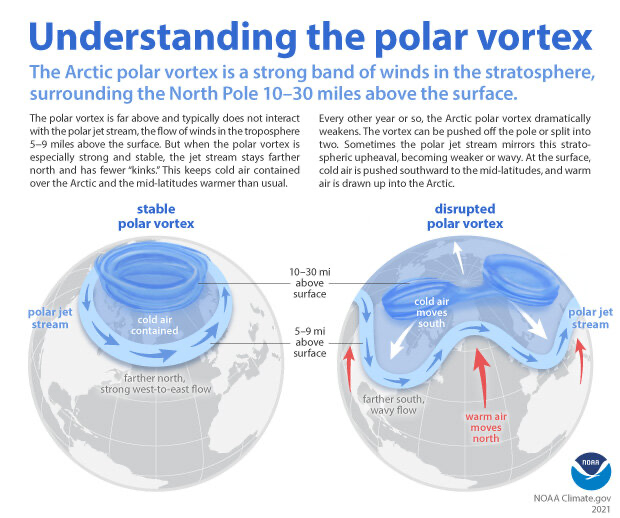
A converted Cold War bomber packed with instruments is investigating atmospheric chemistry and aerosols over the Arctic in an ambitious stratospheric research mission. The project, dubbed SABRE, is part of NOAA’s Earth’s Radiation Budget research program.
— NOAA Climate.gov (@NOAAClimate) 7:00 AM ∙ Mar 28, 2023
climate.gov/news-features/…
Showing some initiative
I like that.
A lightning rod doesn’t wait for the lightning to strike. Less than a millisecond before the lightning touches it, the rod, provoked by the presence of the negative discharge of the lightning, sends a positive discharge up, trying to connect to it.
— NYT Science (@NYTScience) 4:07 PM ∙ Mar 28, 2023
Regional Climate Impacts and Outlooks
We’re nearing the end of March, which means we get a new set of climate impacts and outlooks. If you scroll to the bottom of that linked page, there are links to the regional summaries. Here’s a direct link to the Western region summary.
I was just about to look that up again
Thanks Gerry.
Extratropical cyclone (ˈek-strə trä-pi-kəl ˈsī-ˌklōn )
— Gerry Díaz (@geravitywave) 3:30 PM ∙ Mar 28, 2023
A type of storm formed in middle or high latitudes, in regions of large temperature variations called frontal zones. They are capable of producing anything from mild showers to gales, t-storms, blizzards, and tornadoes. ⛈️
Just one more look.
Simply stunning view of the latest bomb cyclone approaching the U.S. West Coast.
— CIRA (@CIRA_CSU) 6:56 PM ∙ Mar 28, 2023
While we’re here
If bomb cyclone and bombogenesis are terms you keep forgetting to look up (like me), here you go. They’re real weather terms.
Bombogenesis is when a midlatitude cyclone strengthens at a particular rate within 24 hours. Strengthen in this case means the pressure drops. The exact rate is often defined as 24 millibars in 24 hours, but I’ve also read that it can depend on where you are in the world. Either way, when a midlatitude cyclone goes through bombogenesis, it’s called a bomb cyclone. Tada!
A new study!
The video summarizes the article pretty well and has some amazing visuals. Not altogether surprising I guess. Here’s a link to the study itself.
America will probably get more killer tornado- and hail-spawning supercells as the world warms, according to a new study.
— AP Climate (@AP_Climate) 1:00 PM ∙ Mar 29, 2023
"What we’re seeing in the longer term is actually occurring right now." apne.ws/8MRZ4QE
See you next time weather fam!
Weather Feed is a reader-supported publication. To receive new posts and support my work, consider becoming a free or paid subscriber.


